Total Pageviews

Monday, October 21, 2013

Fall Raccoon Creek Paddle

Tucked away in the heart of southeastern Ohio lies the beautiful Raccoon Creek, which meanders through some of the most scenic counties in the state. Due to this region's rich supply of natural resources, Raccoon Creek has suffered from Acid Mine Drainage (AMD), sedimentation and pollution. Fortunately, the Raccoon Creek Partnership (RCP) has since emerged (2007) to provide restoration to this biologically diverse aquatic ecosystem. Prior to the 1800s, this stream was a favorite hunting area for Native Americans who sought white-tail deer, turkey and beaver. Raccoon Creek flows 114 miles from the scenic Hocking Hills region south to the Ohio River.

During the first weekend in September, my friend Grace and I decided to take one last outdoor retreat while the weather was still favorable. Despite the low water level, our plan was to spend the weekend paddling 20 miles down the stream, camping along the way. We knew it would be an adventurous trip as neither of us had paddled Raccoon Creek before and our prediction was correct to say the least. 
We arrived late Friday night at Zaleski State Forest - the most scenic portion of the creek, which is near the headwaters. We decided to hike to Lake Hope via the Hope Furnace trail to camp for the night before putting in nearby early the next morning. We fell asleep to the echoes of beaver smacking their tails all along the lake. As we climbed in our canoe and took off Saturday morning, the abrupt change from civilization to solitude was instantly conspicuous. Over 75% of Raccoon Creek is forested and very well-kept, which really creates a wilderness feel to it. At times, we would stop paddling to listen birds that were beginning their fall migration, breathe the fresh air, and take in the beautiful views.
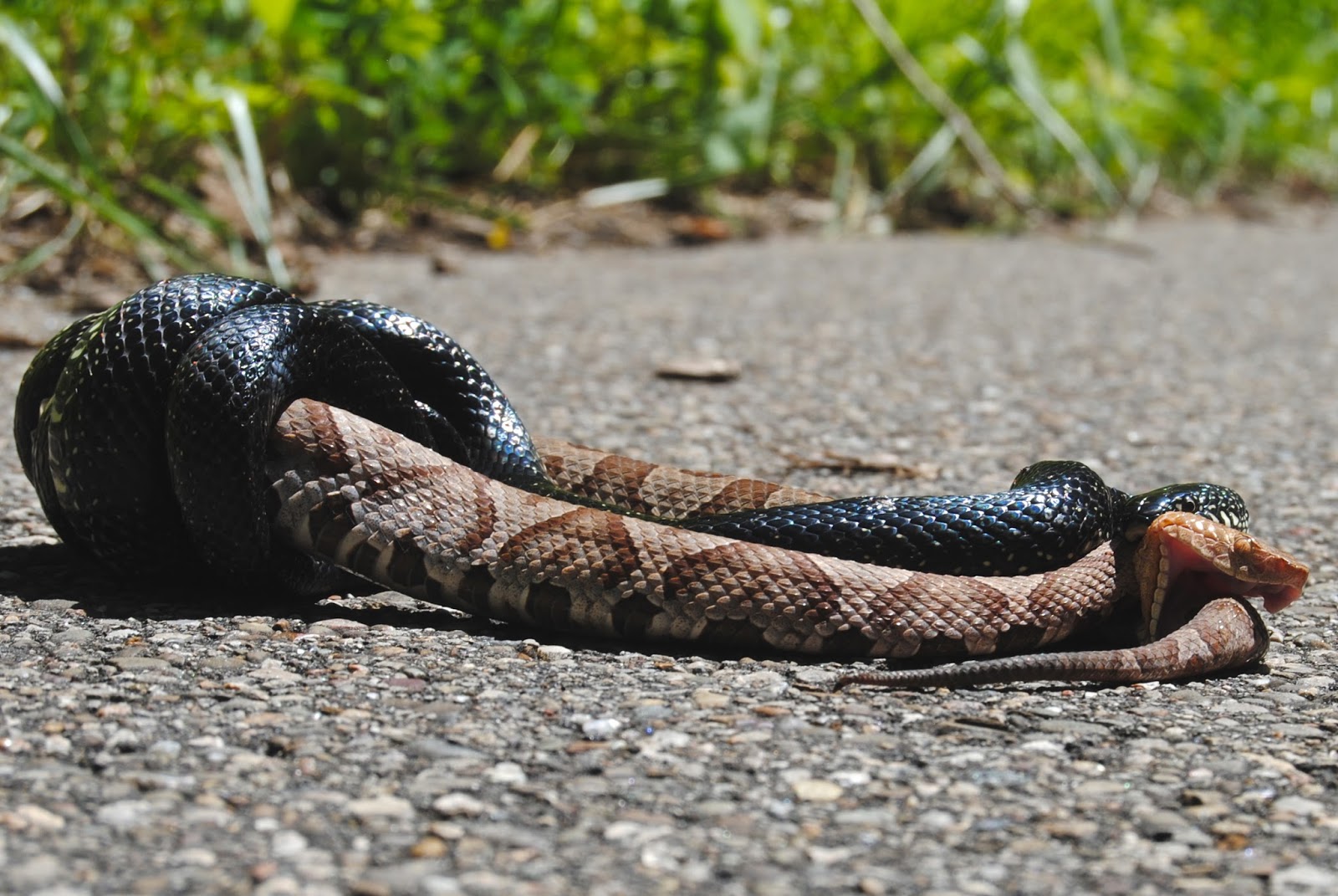
We passed subtle signs of civilization and history here and there, including the historic and haunted Moonville Tunnel, old train trestle remnants from coal operations, and beautiful abandoned logging road bridges and cabins. We were lucky enough to find a healthy supply of paw paws along the way as well (as pictured above).  Paw paws are nicknamed the "Indian banana" and grow best in Ohio and it's surrounding states. Paw paws pack more potassium than most fruits, which provided us with an excellent source of nutrients to keep us fueled up. 
Our first rude awakening came moments after we put our canoe in the clear blue water as we came upon our first portage. We predicted a lot of portages due to the water level but couldn't have imagined the amount and size of the log jams we encountered along the way. All in all, we probably carried our canoe over forty portages! But it was well worth the effort and even added to the trip at times. By the end, Grace and I had a quick and efficient system that worked well for us. The woodland sunflowers and cardinal flower flourished along the banks like weeds.
This area was one of the most beautiful spots we came across. Here, the grade grew steepest, which created small riffles and ankle deep water. This time of year is perfect for this - little to no mosquitos, cool breezes with warm weather and water temperature. The river birch, sycamore and willows shined bright on that day, providing us with the perfect ratio of sunlight to shade. We could only imagine the diversity of darters, aquatic insects and pan fish swinging beside our feet.

After a long day of paddling (10+ miles), Grace and I pulled out canoe up onto a bank where we would pitch our tents, tell stories, and prepare our meal for the night. We couldn't wait to pour a glass of wine and reflect on what we had seen on Saturday. After taking a look at the map, we dozed off early.
Since Grace had to be home by 1pm on Sunday, we awoke very early to get a head start on the clock. Unfortunately, we realized that we had made a mistake in our planning once we had hit route 50 - we knew we had paddled a good distance past our end point. As we reached the route 50 bridge, we decided to leave our canoes and walk the road towards the area where we had parked her car. 

At the time, we were convinced that the car would appear around the next bend. But after 10 or 20 bends, we found ourselves pausing at any and every subtle sound, hoping that a passerby was traveling towards us. We began to switch our efforts to hitchhiking. By that point, we were in Vinton County. We knew that we would likely not see a car until church let out and we were right. But as soon as it did, the very first car that came around stopped. Mr. Wilbur Connely, a preacher for an apostolic church, was kind enough to take us to Grace's car - paddles and all. We were amazed at how far we paddled past our destination - 6 miles in all! But, I must say, it felt like 12 miles because Mr. Wilbur preached more than he was driving. It surely added to the experience. 

I'd recommend Raccoon Creek to anybody seeking a tranquil, scenic getaway in Southeastern Ohio. Of course, the ride is much easier during the rainy seasons but the late summer benefits made our trip well worth the effort. Cheers!

Saturday, July 13, 2013

The King of the Forest

The more I begin to settle in with my new position, the less I find myself in the woods on the hunt for anything wild. But today was a pleasant surprise thanks to my good friend and botanist, Andrew Gibson (The Natural Treasures of Ohio). In fact, this isn't the first time he's pulled me out of my slump and, likewise, it isn't the first time Andrew and I have had an unusually good day as far as extraordinary finds. One of the last times he and I tromped around, we came across two orchid county records in the same day in different locations. Well, today was no different. We hit Adams and Scioto Counties for a chance to see some summer flora. We certainly got what we asked for with a handful of orchids and some extremely rare plants to boot, which I will tackle in a later post. Though, what was most exciting about this trip was our encounter with a heated snake fight. First of all, coming across any two animals fighting in the wild is just plain lucky, let along snakes. But, what made this experience especially extraordinary were the species of snakes involved.
Initially, we thought the black snake was a common black rat snake. But, to our surprise, it turned out to be the rare eastern king snake. After this bout, the name "king" makes perfect sense - trust me. After it finished the copperhead off, it retreated into the woods unremorseful.
Eastern king snakes are known in Ohio only to our most southern counties, where they are uncommon. They are constrictors that prey on a variety of things such as amphibians, eggs, lizards, and other snakes - especially venomous species because they are immune to venom. What a neat species and a great highlight to an excellent day in the field!


Wednesday, March 13, 2013

Endangered Keys Island Plant Find

Earlier today, as I began to dig through pictures from my recent kayak trip to the lower Florida backcountry keys, I came across a cell phone photo that I almost forgot I even captured of a unique plant I came across on a small, remote Island. To give you an indication of how much this plant stuck out to me in a hidden, sandy corner of the island, I made the decision to turn on my cell phone and snap a photo, which was on its last leg and had outlasted my digital camera battery at that point. So, yes, the nerd in me was willing to jeopardize having the security of a cell phone on a kayaking trip in the middle of nowhere to have the opportunity to identify this plant.

Needless to say, this was the last photo I snapped on the trip because my phone died shortly after. But, I'm so glad I did because, otherwise, I wouldn't have realized that I had come across the most rare plant I've seen to date- sea rosemary (Argusia gnaphalodes). In fact, this is the only native Argusia species found in the states.

Sea rosemary can reach 6-feet tall with a 20-foot spread, which is how I found my plant. Extremely tolerant to salt and drought, sea rosemary also prefers full sun. I found this plant in a small opening on the edge of a remote island beach hidden among a patch of red mangroves. The succulent, silky tomentose leaves really stand out and the aromatic flowers, which flower intermittently throughout the year on this evergreen shrub, were in peak bloom. Today, conservation efforts for this dune stabilizing plant are increasing through cultivation.


According to The Institute for Regional Conservation: Florstic Inventory of South Florida Database, this plant has been recorded in Monroe County, which includes the island I found it on. Globally, this plant extends through the Caribbean and into South America - Florida being its northern most range.


Sunday, March 10, 2013

Guana Tolomato Matanzas National Estuarine Research Reserve

For the second time in six months, I visited Guana Tolomato Matanzas National Estuarian Reserve (GTM) in Ponte Vedra, Florida. The northern beach area pictured below contains the highest dunes in Florida along with dozens of other unique and delicate communities that are home to 580 plant species - 8 of which are protected.


Most of what comprises this area is categorized as beach dunes, which are barren, xeric, well-drained soils. Much of the sand it comprised of shell fragments, which makes the sand of GTM so soft and unique. When I visited over the summer, loggerhead sea turtle nests were blockaded off for protection. 


Beach dune communities are categorized as being wind deposited mixed with wave-formed beach upland that is predominately populated with pioneer species, particularly the above-mentioned sea oats (Uniola paniculata). Beach dunes are of course in close proximity to the ocean so its plant communities must be highly tolerant of salt much like sea oats.


Another highly salt-tolerant species had me reminiscing back to my days in North Dakota's prairie cordgrass fields. This prairie cordgrass relative saltmeadow cordgrass (Spartina patens) is another indicator species of the beach dune community - again, another salt tolerant species. 


Further, another salt tolerant graminoid - saltgrass (Distichlis spicata) was not hard to spot throughout the reserve and the keys. I saw this species in North Dakota - saltgrass is also tolerant to alkali conditions. A good fodder for cattle, saltgrass is cultivated using saline irrigation systems in some areas of the country.


Traveling into the grassy barren lands of the beach dunes, you will quickly notice two cacti species - the most plentiful being cockspur pricklypear (Opuntia pusilla). You may find this one painfully by accident like I did. Unlike other cacti species, the thorns of cockspur prickly pear are barbed and can be embedded in the skin - trust me, I know :). In addition, the segments can easily detatch as a means of dissemination. This species, like other Opuntia spp., suffers from the infestation of the invasive cactus moth (Cactoblastis cactorum). 


The other cactus species you will find is the nobel erect pricklypear (Opuntia stricta). Both species are relatives of Ohio's only cactus species, eastern pricklypear (Opuntia humifusa). This species has become a serious problem in other countries and has prompted the release of the aforementioned cacti moth, which has hurt this plant in its native distribution.


Blanketflower (Gaillardia pulchella) can be seen throughout the beach dune community as well. This species is widespread but different from the northern species (G. aristata) I encountered in most prairies throughout North Dakota. Like its relative, G. pulchella is highly drought tolerant and prefers well-drained soil. G. pulchella differs morphologically by being more red than yellow, unlike its northern relative.


Tread softly or "finger rot" (Cnidoscolus stimulosus) is a nasty little poisonous plant of the Euphorbiaceae family. It is not a true nettle but its hairs can cause a severe rash to some. This little plant prefers well drained soils and is often found in coastal dune habitat throughout the south.


Much like the cacti, this thistle stuck out like a sore thumb among the beach dune plants. I've never seen such a robust thistle than this horrible thistle (Cirsium horridulum). Look at all those spines! It's no wonder why this species is named the way it is.


Guana Tolomato Matanzas will continue to keep me coming back for its soft wave-tumbled shell beaches, luch biodiversity, and vast continuum of blue-green water colors. Not to mention, this section of beach never fails to line my pockets with shark teeth. This is one of the prettiest areas I've ever been to - another hidden gem of Florida.

Saturday, March 9, 2013

Lower Keys Backcountry Kayak/Camp Excursion

Outdoor excursions allow you to traverse an area in its rawest form often in a way that only local people have the chance of experiencing, rather than viewing it from afar through a high-rise hotel window. Not to mention, if done right, backpacking trips can allow you to save big bucks! With the right preparation and attitude, a well-thought-out trip can offer a glimpse into an area's flora, fauna, culture and environment. During my latest trip, I led five friends and family on a 25-mile minimalist kayak/camp trip into the backcountry of the Florida Keys.
A typical guided trip in the area costs $1000/person. This is understandable given the time a guide would need to invest in leading a multi-day trip but, since we had our own backpacking and orienteering experience, we asked for a reduced rate to use the kayaks without a guide. Instead, we rented kayaks for $125/person for 5-days. Between that cost, gas for travel and food/water, we each only spent $400 for the week-long trip.

After the kayaks were reserved, the fun planning came as I dove into the area's rich flora, fauna, geology, and culture. My personal list of objectives quickly grew as I learned about the indigenous stone crab and keys pink shrimp delicacies. And, with the money I saved by choosing an unguided kayak rental rate, I decided to budget for a fishing rod. After all, I'd be spending my spring break in the fishing capitol of the world. This pack weighed between 12 - 15lbs before adding food, and we each put 3-4 jugs of water in the storage compartments of our kayaks.


Day 1 (Mar 3) We were welcomed to Sugarloaf Key by rainfall at around 11pm on March 2nd. Exhausted from a long drive, we quickly threw up a couple of tents and hit the hay. We woke up to quickly pack the food we had bought the night before and barley made it out by 8:15a to meet the kayak livery owner. As he dropped us off with the kayaks, a front moved in and pounded us for an hour before quickly burning off like most storms in the Keys. Before long, we were off to the races. We launched from Blimp Road on Cudjoe Key and passed by a military blimp from the US's smallest air force base, used for reconnaissance in drug cartel projects.


A look at Tarpon Belly Key in the distance. One of the shortest paddles proved to be of the most difficult due to the head-on wind from the northwest.


Shortly before reaching Tarpon Belly Key, I caught a nice sea trout that we sautéed in olive oil and spices mixed with Idahoan instant potatoes - hit the spot! At night, we tossed bait and lures into one of the old shrimp hatchery pools and caught mangrove snappers and pin fish. Years ago, the island was dredged to form these shrimp hatcheries. The hatcheries are now just channels that divide the island. During high tide, there was a lot of fish activity in there (mostly mangrove snapper, needle fish and baby tarpon).

Day 2 (Mar 4) We woke up early to calm westerly winds so we decided to stick to our original game plan and paddle all the way to Marvin's Keys (8 miles away) despite being sore from the first day of paddling. I am still so proud of the group for not only taking the challenge but conquering it. Along the way, I caught a nice-sized Jack that I cooked up for everybody on Johnston Key.


Further along we spotted adult loggerhead sea turtles and jumping dolphins as close as 6 feet away from the boat! The gentle wind pushed us along nicely and allowed us to relax a bit and look around at the beautiful coral beds beneath our boats. With Marvin Key in sight, we stopped off at a beautiful white sand shoal off of barracuda keys. We collected shells and sand and relaxed before making our final leap towards Marvins Keys.  


We made great time and set up camp around 4pm. Our campsites were on the northeastern side of the smaller key, overlooking the beach. What a beautiful campsite! That night, we claimed an old recreational stone crab trap buoy and carved our names into it for a souvenir. Salt grass made for great bedding for my tent.


This is the coolest, most southern benchmark I've ever encountered. This was sitting alongside a clean path through a saltgrass meadow on the island. Marvin Key is one of the lower Keys' greatest hidden gems.


That night, we made a nice fire and sipped on bagged wine. Bagged wine is cheap and proved to produce one of the greatest hangovers I've ever encountered - butttt, it's nice and packable! I pointed out some of the constellations and a few of us took a walk out to the flats to get a better look. The stars were as clear as I've ever seen them.


Day 3 (Mar 5) I woke up well before everybody else to get some fishing in. to get to the other side of the island where the famous shoals are during low tide, I had to walk through a trail, which took me through a patch of mangroves - very pretty. It was me and the keys fishing together. At one point, I got spooked by a 4-foot sand shark that had snuck up on me. No fish but a beautiful morning on one of the Florida Key's best kept secrets. People began to wake up around 9am. I made my sister coffee and jumped in a double kayak with her to get her some fishing time. We paddled into a nice grove of mangroves where we saw egrets, pelicans, plovers, white ibises, blue herons, and needlefish. I picked up a big hermit crab for her to see. On the way back, it got too shallow so I pulled her around the island where we were confronted by a brave territorial reddish heron. We must have been near its nest. As we passed, it quickly went back to fishing.


Day 4 (Mar 6) We decided to skip our final remote key destination (snipe keys) to paddle straight to Sugarloaf Key for some real food and pina coladas! What was supposed to be an 8-mile trip turned into nearly a 12-mile trip from trying to figure out which side of Sugarloaf Key the KOA was on. We paddled across Turkey Basin where we saw more sea turtles. Our trip across the channel was beautiful as we passed over crystal clear, calm water and lush coral beds towards the old bridge. That night, we bought four pizzas, two orders of buffalo wings, and plenty of cold drinks. The Sugarloaf KOA was cheap and welcoming with showers, laundry, a pool, hot tub, cafe, and outdoor bar. Sue from Big Pine Key Kayak Adventures met us there to pick up our kayaks in the morning. We enjoyed breakfast sandwiches and news of a big storm up north before heading out to Key West. We got to our hotel around 1pm and ate lunch at the Island Dog restaurant. We checked out Margaritaville and had excellent food at the Conch Republic. I got the snapper melt.


Day 5 (Mar 7) Our last day in the keys, Destini and I saw the southern most point and drank coconut milk right out of the fruit while biking down side roads. Michelle, Rachel, Destini and I visited Earnest Hemmingway's house and we each bought ourselves a small painting from a guy named scott from Boston. He gave us a big discount because of my Red Sox hat. Destini and I finished the trip at Alonzo's Oyster Bar by trying 1/2 lb of stone crab, a bucket of clams, and conch ceviche. It was tough to say bye to the keys but it is satisfying to know that we saw everything and more that we wanted to see.