Total Pageviews

Showing posts with label Backpacking. Show all posts

Thursday, July 3, 2014

Dolly Sods Wilderness on Fire

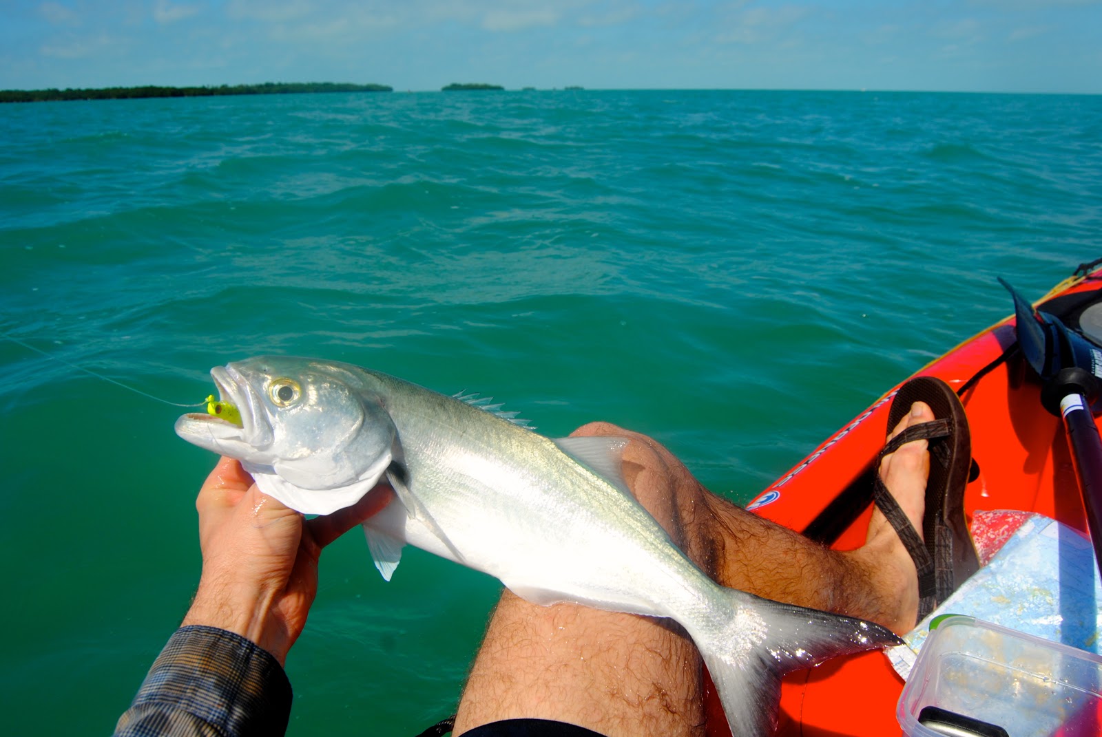
I admit, moving from the east coast (Massachusetts) was pretty tough and, at times, I'd do anything to be back. There's just something unforgettable about driving up to Cape Cod with your good friends for a night of striped bass fishing off of a jetty overlooking Woods Hole. The sights, sounds and smells of the full moon above, waves crashing below and the electric splashing of herring in the distance turning on like the flick of a light switch, as they fend for their lives from the predators below. Slack tide has arrived in the "Great Harbor."

But there is something unforgettable about any place, really. Despite what some of my hometown friends say, the midwest ain't nearly as bad as they think. The cost of living, sense of community, scenery and the close proximity to pretty much anywhere else in the country is second to none here in the rolling hills of Southeastern, Ohio. And having lived here for seven years, I've been fortunate to keep that perspective fresh as I take full advantage of the endless opportunities around me.

In the past seven years, I've been blessed to see many different areas in a number of states; yet, two places have stood out to me like no other. One of them is the backcountry keys of Key West, Florida and the other is Dolly Sods Wilderness in the Monongahela National Forest of West Virginia. When I truly gain a love for an area, there's a good chance I'll be back. So, the backcountry keys have taken the place of my spring break for the past two years and Dolly Sods has been my autumn destination for the past three years, with a handful of trips and memories there in between. There's just something amazing about this place in the fall that keeps me coming back with different groups of friends each time.

During this past fall, I was lucky to finally have the same weekend off as three of my favorite travel friends - Alexa, Alex and Lakota (the Germain Shephard). Alex spent summers in the north woods guiding boyscout groups through the Boundary Waters Canoe Area Wilderness and through Quetico, Canada. Alexa has traveled all around the country to research bats as part of a private consulting company. It's always great traveling with Alexa because she is so laid back and Alex is completely full of survival information and great stories. On down the road, four and a half hours fly by as we become taken back by the increasingly growing and colorful hills mixed with a slough of good bluegrass tunes from each of our playlists.


As I picked up on at an early age, no matter how many times you visit the same place, or look up at the same sky, the only thing that will remain the same is the memory that you've kept from before. Otherwise, you have no idea what to expect the next time. That held very true during this trip as we were consumed by a dense, refreshing fog throughout most of the hike. And to many, this might put a damper on an ordinarily scenic trip like this, like trips I've experienced there before; however, it only made the area  come to life in a different way -- everything changes. This old wind blown cherry tree tells a story, perhaps many, as it it protected from encroachment of other trees by a sea of azalea and blueberry shrubs. I know one thing: this would be a sight to see had I lost my compass as the wind blows from the west in the Northern hemisphere, hence "westerlys." Perhaps it's telling me to head east, back home?

Dolly Sods sits along the Allegheny Plateau and is made up of many of the same temperate plants and animals found here in Southeastern, Ohio. This makes complete sense since we are so close to West Virginia. Although, what makes this place so surreal and unique from the rest of the midwest is its elevation. Everything is stunted here and there is little tolerance for hardwood forests because of the harsh climate from being of the subarctic tundra. Although, when you do finally come across a woodlot, my oh my! The beeches and maples and mist and northern birds had me dreaming of the very place I was standing at.

As we traveled from Blackbird Knob trail (the usual meander from year to year), the crew decided to veer off for a trek via Daubenmire Glade. For those that don't know, a glade is basically an area of vegetated land that sits right on top of bedrock; which, in this case, happens to be white sandstone made up of quartz, making it light in color. At first, it reminded me very much of that granite back in Massachusetts. But notice that weathering of the boulders. Granite endures abrasion much better than sandstone because it is an igneous rock (created by heat or lava) as sandstone is sedimentary. I always love finding plants for the first time in far off places that I've only read about, like this red elderberry. This plant is native in Ohio but not common and inedible, unlike some of its relatives.

In years past, I've been lucky to kick up a flock of ruffed grouse, a vibrant mud salamander, and even bears on forest roads leading into the wilderness. Some say to travel here during parts of the summer to see black bears foraging on the miles of blueberry and huckleberries. I don't think there's anything better than homemade blueberry pancakes under an old stand of pines...mmmm. So we happened to find this fat guy on the trail. He needs to lay off the blueberries for sure.

 And even more common than the abundance of wildlife that we see is the many edible plants that we find. I already mentioned blueberry and huckleberries. We also trip over our fair share of teaberry, cranberry, and edible mushrooms along the way. Rose hips and pine needles provide a huge vitamin-c boost as well. 

And finally, during our last night in the wilderness, we bumped into some fellow ohioans and shared some whisky and lies over the damp fire. Apparantly I woke up in the middle of the night screaming at the top of my lungs haha. I don't know what that was about but everybody thought there was a bear in the campsite when I didn't answer the first time, until it kept happening of course haha. But hey, back to the point of the story --look at the view from that campsite!!! What a great trip with excellent company. I feel blessed to have this one on my belt.


 Cheers --

Thursday, March 27, 2014

Cumberland Island National Seashore - WIlderness Trek

On the way back up from our Key West backcountry paddle trip, we decided to stop by the Everglades before spontaneously deciding to pull an all night detour up to Georgia's Cumberland Island National Seashore, which has long been on my bucket list of places to backpack. To summarize in one paragraph why this 23,000 acre island is such a gem of a place would be both difficult and omissive. So I'll dedicate this blogpost not only to describing the highlights and details of our trip, but also the history, biodiversity, geology, and intrinsic value of this site.

As you pull into St. Mary, Georgia, you're greeted by beautifully restored 17th and 18th century buildings wrapped in cedar shingles. The atmosphere brought back memories from my time living on the north shore of Massachusetts, particularly memories in and around the Gloucester area. This old town is very well-kept with waves of character. The main strip ends at the entrance to the St. Mary's ferry, which is the only means of transportation to and from the island. Despite highly recommended reservations in advanced, we were able to squeeze onto the 45 passenger vessel with only one spot remaining. The island itself only allows a maximum of 300 people on the island at one time - a fraction of those are able to purchase an overnight permit. That's not very many people for an area larger than Manhattan! Although, the island rarely experiences that many visitors at one time.

The 45 minute ferry ride amounted to a picturesque glide across the glassy cumberland sound and the ferry was filled with men, woman, children and a slough of lightweight backpacking gear for those who craved a bit more adventure than a day's hike near the dock. The trip back produced goodbyes from a group of playful dolphins at our gunnels to a curious laughing gull that followed us back.

Our trip was divided into two long days. 

Day 1: we began on the parallel trail, which meanders through acres of healthy maritime forest, predominately made up of live oak and palmetto. This ecological community is sometimes referred to as a hammock. We eventually made our way to Stafford Beach, where we exited the forest and walked north, close to 8 miles of the longest barrier island beach (17.5mi) in Georgia. Eventually, we doglegged over via South Cut Trail to find the main road, which led us to the furthest primitive campsite on the island's wilderness - Brickhill Bluff. All in all, we hiked a total of 13.4mi over a span of 8 hours for the first day.

Day 2: We knew we had to catch the 2:45p ferry so we woke up early to get a head start. With sore hips and aching blisters, we decided to take the main road back, which would cut our second day down to 10.3 miles. Along the way, we passed one group of hikers from Pennsylvania who were haphazardly walking with their heads down. Come to find out, they were searching for sharks teeth. Soon after, we were doing the same thing, lining our pockets with the old dark fossils including those of macko, sand, and lemon sharks - some even of extinct species. The island is compiled of 50 miles of backcountry trails - we covered just under half of them in almost 28 hours (including sleep!).

This healthy maritime forest is mostly occupied by live oak and palmetto. The canopy sealed off just enough light to produce perfect, cool conditions to endure such a long trek. Despite what many sources say, Cumberland Island is not the largest barrier island in Georgia; however, it contains the largest tract of upland habitat and the longest beach of them all. If you factor in marshland, Ossabaw and St. Simon take the cake for overall size. Although this forest is steadily growing towards a climax forest via succession, it was once much healthier during pre-settlement. Most of the island was actually logged for ship building and shingle manufacturing, among other land uses. 

Soon after connecting with the beach via the Stafford Beach trail, we decided to take a lunch break for some hearty calories (mashed potatoes and tuna). We spent hours walking the shoreline combing the islands rich supply of seashells, littered about like colorful Christmas ornaments ready to be hung on Black Friday. On the east coast, the winter months always provide the best shelling opportunities so we were having a field day identifying the wide variety of species. Just as Alexa found a lined starfish, Kaitlyn pointed to a bald eagle feeding on a decaying skate as we tripped over an aboveground cemetery of horse shoe crabs and cannonball jellyfish. We found dozens of lettered olives, lightening and knobbed welks, a handful of mottled purse crabs and a wallet full of sand dollars to boot. 

When traveling long distances, especially on sand, it might be more beneficial to walk barefoot. At the end of the trip, Alexa paid the price for wearing her "five fingers" Vibram soled shoes, especially since sand kept getting trapped between the shoes and her feet. Kaitlyn did well with her running shoes until we had to cross dune areas. Ultimately, this was a tremendous trip and challenge that the crew handled very well. It's always much easier traveling with laid back people who are able to go with the flow. After all, surprises, setbacks and learning to deal with the unexpected is truly half of what we are out there for. I couldn't give more credit to this awesome crew for stepping up.

Another category that Cumperland Island is superior in is the high level of biodiversity. With an old Pleistocene (1.8mil - 10,000ya) geological regime throughout most of the island (especially the northern portion), the island's soil is very mature, allowing for a wide range of species. In contrast, harsher environments with poorer soils such as deserts and the boreal forest tend to support less biodiversity. One of the highlights on the trail was finding scores of corral root orchis. The live oak-palmetto hammock sporadically changed into slash pine forest as well as the occasional old growth red cedar.

At some points, we found ourselves with our heads down hundreds of feet apart from each other without realizing it until we made a cool discovery that we wanted to share, such as this decaying wild boar. Cumberland Island is really one of the most historic sites in America rich in archeology findings, to evidence of the war of 1812 to remnants of old slave buildings. Unfortunately with people came domesticated animals such as hogs and horses, which have seen become ferrel and continue to roam the island. Although they are quite the site to see and largely add to the character of this place, they take their toll on the fragile dune systems and native flora and fauna. For example, Cumberland Island is the largest breeding area for the endangered loggerhead sea turtle, which holds as many as 200 nest sites; although, wild boar have additionally damaged this already threatened population. The National Park Service recognizes this and has created a management plan to reduce populations.

Cumberland Island is home to approximately 140 wild horses, which are best observed throughout the dunes. We spent hours looking for horses until we were surprised by this small population grazing on grasses - they were surprised to see us as well.

Alexa and Kaitlyn looking west as we found our first population of wild horses. Quite possibly, the abnormally large and non-vegitated dune that they are standing on could have been caused by a combination of human impact such as logging, and exotic animal species.


Finally, we were able to reach Brickhill Bluff in just over 8 hours after stepping foot off of the ferry. This spot always tends to have more gnats than the others but we decided to make the trek for the sunset, which we just barely caught, and for the challenge of hiking to the furthest campsite in the backcountry wilderness. We were rewarded with this beautiful view of St. Mary's river, Brickhill river, and the Cumberland sound. Excellent trip!

Saturday, March 9, 2013

Lower Keys Backcountry Kayak/Camp Excursion

Outdoor excursions allow you to traverse an area in its rawest form often in a way that only local people have the chance of experiencing, rather than viewing it from afar through a high-rise hotel window. Not to mention, if done right, backpacking trips can allow you to save big bucks! With the right preparation and attitude, a well-thought-out trip can offer a glimpse into an area's flora, fauna, culture and environment. During my latest trip, I led five friends and family on a 25-mile minimalist kayak/camp trip into the backcountry of the Florida Keys.
A typical guided trip in the area costs $1000/person. This is understandable given the time a guide would need to invest in leading a multi-day trip but, since we had our own backpacking and orienteering experience, we asked for a reduced rate to use the kayaks without a guide. Instead, we rented kayaks for $125/person for 5-days. Between that cost, gas for travel and food/water, we each only spent $400 for the week-long trip.

After the kayaks were reserved, the fun planning came as I dove into the area's rich flora, fauna, geology, and culture. My personal list of objectives quickly grew as I learned about the indigenous stone crab and keys pink shrimp delicacies. And, with the money I saved by choosing an unguided kayak rental rate, I decided to budget for a fishing rod. After all, I'd be spending my spring break in the fishing capitol of the world. This pack weighed between 12 - 15lbs before adding food, and we each put 3-4 jugs of water in the storage compartments of our kayaks.


Day 1 (Mar 3) We were welcomed to Sugarloaf Key by rainfall at around 11pm on March 2nd. Exhausted from a long drive, we quickly threw up a couple of tents and hit the hay. We woke up to quickly pack the food we had bought the night before and barley made it out by 8:15a to meet the kayak livery owner. As he dropped us off with the kayaks, a front moved in and pounded us for an hour before quickly burning off like most storms in the Keys. Before long, we were off to the races. We launched from Blimp Road on Cudjoe Key and passed by a military blimp from the US's smallest air force base, used for reconnaissance in drug cartel projects.


A look at Tarpon Belly Key in the distance. One of the shortest paddles proved to be of the most difficult due to the head-on wind from the northwest.


Shortly before reaching Tarpon Belly Key, I caught a nice sea trout that we sautéed in olive oil and spices mixed with Idahoan instant potatoes - hit the spot! At night, we tossed bait and lures into one of the old shrimp hatchery pools and caught mangrove snappers and pin fish. Years ago, the island was dredged to form these shrimp hatcheries. The hatcheries are now just channels that divide the island. During high tide, there was a lot of fish activity in there (mostly mangrove snapper, needle fish and baby tarpon).

Day 2 (Mar 4) We woke up early to calm westerly winds so we decided to stick to our original game plan and paddle all the way to Marvin's Keys (8 miles away) despite being sore from the first day of paddling. I am still so proud of the group for not only taking the challenge but conquering it. Along the way, I caught a nice-sized Jack that I cooked up for everybody on Johnston Key.


Further along we spotted adult loggerhead sea turtles and jumping dolphins as close as 6 feet away from the boat! The gentle wind pushed us along nicely and allowed us to relax a bit and look around at the beautiful coral beds beneath our boats. With Marvin Key in sight, we stopped off at a beautiful white sand shoal off of barracuda keys. We collected shells and sand and relaxed before making our final leap towards Marvins Keys.  


We made great time and set up camp around 4pm. Our campsites were on the northeastern side of the smaller key, overlooking the beach. What a beautiful campsite! That night, we claimed an old recreational stone crab trap buoy and carved our names into it for a souvenir. Salt grass made for great bedding for my tent.


This is the coolest, most southern benchmark I've ever encountered. This was sitting alongside a clean path through a saltgrass meadow on the island. Marvin Key is one of the lower Keys' greatest hidden gems.


That night, we made a nice fire and sipped on bagged wine. Bagged wine is cheap and proved to produce one of the greatest hangovers I've ever encountered - butttt, it's nice and packable! I pointed out some of the constellations and a few of us took a walk out to the flats to get a better look. The stars were as clear as I've ever seen them.


Day 3 (Mar 5) I woke up well before everybody else to get some fishing in. to get to the other side of the island where the famous shoals are during low tide, I had to walk through a trail, which took me through a patch of mangroves - very pretty. It was me and the keys fishing together. At one point, I got spooked by a 4-foot sand shark that had snuck up on me. No fish but a beautiful morning on one of the Florida Key's best kept secrets. People began to wake up around 9am. I made my sister coffee and jumped in a double kayak with her to get her some fishing time. We paddled into a nice grove of mangroves where we saw egrets, pelicans, plovers, white ibises, blue herons, and needlefish. I picked up a big hermit crab for her to see. On the way back, it got too shallow so I pulled her around the island where we were confronted by a brave territorial reddish heron. We must have been near its nest. As we passed, it quickly went back to fishing.


Day 4 (Mar 6) We decided to skip our final remote key destination (snipe keys) to paddle straight to Sugarloaf Key for some real food and pina coladas! What was supposed to be an 8-mile trip turned into nearly a 12-mile trip from trying to figure out which side of Sugarloaf Key the KOA was on. We paddled across Turkey Basin where we saw more sea turtles. Our trip across the channel was beautiful as we passed over crystal clear, calm water and lush coral beds towards the old bridge. That night, we bought four pizzas, two orders of buffalo wings, and plenty of cold drinks. The Sugarloaf KOA was cheap and welcoming with showers, laundry, a pool, hot tub, cafe, and outdoor bar. Sue from Big Pine Key Kayak Adventures met us there to pick up our kayaks in the morning. We enjoyed breakfast sandwiches and news of a big storm up north before heading out to Key West. We got to our hotel around 1pm and ate lunch at the Island Dog restaurant. We checked out Margaritaville and had excellent food at the Conch Republic. I got the snapper melt.


Day 5 (Mar 7) Our last day in the keys, Destini and I saw the southern most point and drank coconut milk right out of the fruit while biking down side roads. Michelle, Rachel, Destini and I visited Earnest Hemmingway's house and we each bought ourselves a small painting from a guy named scott from Boston. He gave us a big discount because of my Red Sox hat. Destini and I finished the trip at Alonzo's Oyster Bar by trying 1/2 lb of stone crab, a bucket of clams, and conch ceviche. It was tough to say bye to the keys but it is satisfying to know that we saw everything and more that we wanted to see.

Thursday, October 11, 2012

Dolly Sods on Fire

Heading east from the rolling hills of southeastern Ohio, fiddling blues and folk rock filled the car and the minds of three like-minded people who are connected by a deep fascination for the outdoors - each equipped with their own perspective on nature to create a well-rounded, inspiring atmosphere. As hills grew into mountains, the entrance to God's country appeared quicker than our ears could pop. Color greeted us at the gates from a palette full of anthocyanin, carotene, and xanthophylis pigments. We arrived with our headlamps guiding our path, hinting towards an unfamiliar landscape through moonlit red spruce treetop silhouettes. By morning, a sense of shock seemed commonplace as we sat and built a warm fire beneath a grove of colorful, stunted blackgum trees -  eggs, bacon, and summer sausage would fuel a long day of hiking.

 I've wandered through no other place as vibrant during autumn as the sub-arctic tundra of Dolly Sods Wilderness Area in northern West Virginia. I hiked the same trails exactly one year from this past weekend; though, the views seemed completely fresh as this weird-weathered year continues to bring surprises. Rather than last year's colorful forest canopy, the low-growing understory and meadow plants seemed to be burning brighter this year probably due to such a dry spell, which helped trees shed their leaves much quicker.
We moved through the upland sods with the falling leaves. Mountain oat grass, hay-scented fern, and blueberries created an enchanting weekend for Kaitlyn and Alex who have never experienced Dolly at her best. Alex (a former guide at the Boundary Waters Canoe Area Wilderness of the northern woods) and Kaitlyn (a prolific rock climber and trip leader at Hocking College Outdoor Pursuits) both thanked me by sharing stories and teaching me about camp-cooking tricks and "leave no trace." It's so rewarding to have the chance to share a place as beautiful with good friends.
Golden carpets of hay-scented fern provided a beautiful aroma along the trails. These ferns not only out compete other plants through forming dense colonies, but also through their alleleopathic chemical composition, which inhibits growth of even the mightiest of tree species like oaks.
From the meadows to the forests, biodiversity means color during autumn. My home-state of Massachusetts was well represented with its state fower, "mayflower," mixed in with bristly dewberry, deer moss, sphagnum moss, and blueberry leaves. Beach-maple forests lit up the normally darkened woodlots.
Early on, we were graced with a heavily anticipated show from the sun.
A photo from the same spot exactly one year later. This year, blueberry leaves and quartz deposits added an extra element of beauty at Bear Rocks overlooking the alluring Allegheny plateau. The geology is made up of white sandstone.
Within minutes upon arrival to this view, we were quickly swept with a familiar sight of billowing fog rolling up from the valley. Instantly, we were able to fully understand the presence and power of sub-arctic tundra weather - Dolly Sods.